The Big Freeze: Houston Shivers Under Arctic Blast and Brisk Skies
A Frigid Start to the Weekend
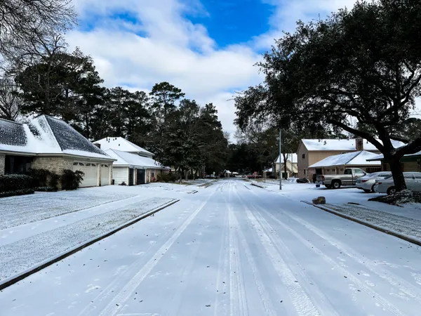
Houstonians waking up this Saturday, January 31, 2026, are facing some of the coldest temperatures of the winter season as an Arctic air mass, associated with the historic Winter Storm Fern, settles over Southeast Texas. Following a night of lingering moisture and icy patches on some area roadways, the precipitation has officially exited the region. However, the primary story today is the biting cold. Early morning temperatures started near a brisk 34°F, but the real story is the wind chill. A Cold Weather Advisory was in effect throughout the morning hours as northerly winds made it feel as though temperatures were in the low teens and 20s across the metro area.
Clear Skies, Chilly Winds: The Afternoon Outlook
Despite the arrival of clear, sunny skies, residents should not expect much relief from the sun. The afternoon high is only expected to reach approximately 44°F. Strong winds from the north will continue to blow at a steady 15 to 20 mph, with occasional gusts reaching up to 27 mph. These blustery conditions mean the "feels like" temperature will struggle to rise above the mid-30s all afternoon. Outdoor activities are discouraged unless you are dressed in significant layers. For those heading out, visibility is excellent and air quality remains high, but the dry air may cause minor skin and sinus irritation.
Evening Plunge: Preparing for a Hard Freeze
As the sun sets this evening, temperatures will plummet rapidly. By tonight, Houston is expected to enter a dangerous cooling phase. A Freeze Watch has been issued to take effect starting at 9:00 PM tonight and lasting through Sunday morning. Forecasts indicate that actual temperatures will drop into the low 20s, and potentially the upper teens in inland suburbs like Conroe and Katy. This puts the region into "hard freeze" territory, where the threat to exposed plumbing and sensitive vegetation becomes critical.
Active Alerts and Safety Notices
Several weather advisories remain in effect to guide residents through this weather event:
- Freeze Watch: In effect from 9:00 PM tonight until 9:00 AM Sunday. A hard freeze is likely, with temperatures between 18°F and 24°F.
- Small Craft Advisory: Winds of 20-25 knots and rough bay waters make conditions hazardous for smaller vessels in Galveston and Matagorda Bays.
- Low Water Advisory: Unusually low tides are expected in the upper portions of local bays, increasing the risk of vessel grounding.
The National Weather Service and local officials urge everyone to protect the four P’s: People, Pets, Plants, and Pipes. Ensure outdoor faucets are covered, pets are brought indoors, and space heaters are used safely and away from flammable materials. While the region avoids further rain or snow today, the extreme cold remains a significant threat through the remainder of the weekend.