Ice and Iron: Houston Shivers Through Final Hard Freeze Before Afternoon Thaw
Frigid Start with Extreme Cold Warning
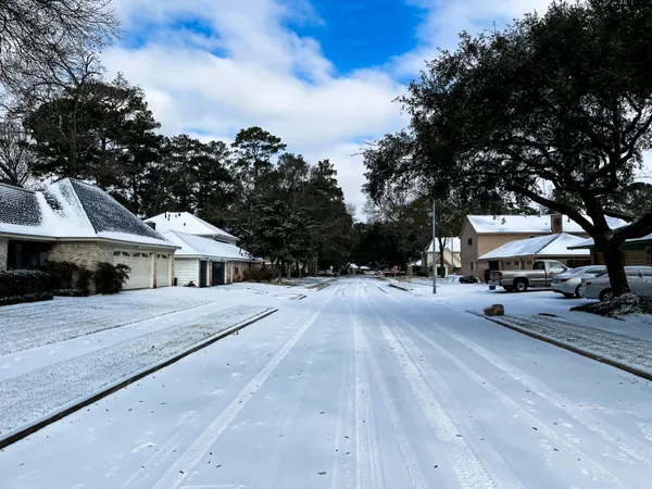
Houstonians woke up to some of the coldest air of the season this Tuesday, January 27, 2026. The National Weather Service has extended an Extreme Cold Warning for the Greater Houston area through 12:00 PM today. Following an overnight arctic blast, temperatures in the early morning hours plummeted into the low 20s across much of the city, with inland areas north of Highway 105 reporting bone-chilling figures in the low teens. The combination of these temperatures and a lingering northerly breeze has resulted in wind chill values between 10 and 15 degrees Fahrenheit.
Local officials and meteorologists are describing this as the "final hard freeze" of the current weather system. Emergency alerts remain active, urging residents to continue their protective measures for the four P's: people, pets, plants, and pipes. The deep freeze has been severe enough to pose a significant risk to exposed plumbing and sensitive vegetation, and residents are advised to keep their faucets dripping until the mercury safely clears the freezing mark later today.
Afternoon Thaw and Sunny Intervals
The good news for those tired of the sub-freezing conditions is that a gradual warming trend is expected to begin this afternoon. Forecasters predict that skies will remain mostly cloudy through the midday hours before some clearing occurs. Temperatures are expected to finally climb above the 32-degree threshold around 1:00 PM, eventually reaching a daytime high of approximately 46 degrees Fahrenheit. While still crisp, this represents a significant improvement over the morning’s arctic conditions.
In addition to the temperature concerns, a Low Water Advisory is in effect for coastal regions. Strong northerly winds continue to push water out of Galveston Bay and Matagorda Bay, resulting in significantly below-normal water levels. Mariners are warned to navigate shallow waters with extreme caution, as these conditions create hazardous navigating environments in the bays.
Clear Skies into the Evening
As we move into the evening hours, the sky is expected to clear completely. While the absence of cloud cover often leads to rapid cooling, tonight is projected to be slightly less intense than previous nights. Evening temperatures will hover in the 30s, eventually dipping back into the upper 20s or low 30s by early Wednesday morning. However, this is expected to be the tail end of the freezing streak, with a more substantial warmup forecasted for the remainder of the week.
Residents should stay vigilant through the remainder of the warning period. Key safety reminders include:
- Ensure all outdoor pets have been brought inside or provided with heated, insulated shelter.
- Keep several layers of clothing on if you must go outdoors before noon.
- Maintain pipe insulation and keep cabinet doors open to allow warm air to circulate around indoor plumbing.
- Check on elderly neighbors who may be struggling with heating their homes.