Houston’s freezing risk is fading, but sub-32 temperatures remain possible later this winter season
Warm stretch arrives, but winter freeze risk is not fully over
Houston is moving into a milder pattern in mid-February, reducing the near-term risk of temperatures dropping to 32°F or lower. Forecasts through Feb. 19 show overnight lows generally in the 50s to low 60s, with daytime highs in the 70s—well above freezing. That trajectory suggests no imminent freeze for the city in the coming days.
Even so, history shows that the question “Is Houston done with freezing temperatures?” rarely has a definitive answer before winter ends. Freezes are uncommon along the upper Texas coast compared with inland Texas, but they remain possible into late February and, in rare cases, into early April.
What “done with freezes” means in Houston’s climate records
A freeze is typically defined as an air temperature of 32°F or lower, measured at official observation sites. In Houston, the statistical window for freezes extends beyond mid-February, even if the odds decline as the season advances. Long-term climate summaries place Houston’s average last freeze in the second half of February, while the latest last freeze in the modern record has occurred in early April.
Seasonal variability also matters. Some winters deliver few or no freezes at the city’s official site, while others bring multiple freeze mornings. A delayed first freeze does not, by itself, rule out a late-season cold intrusion.
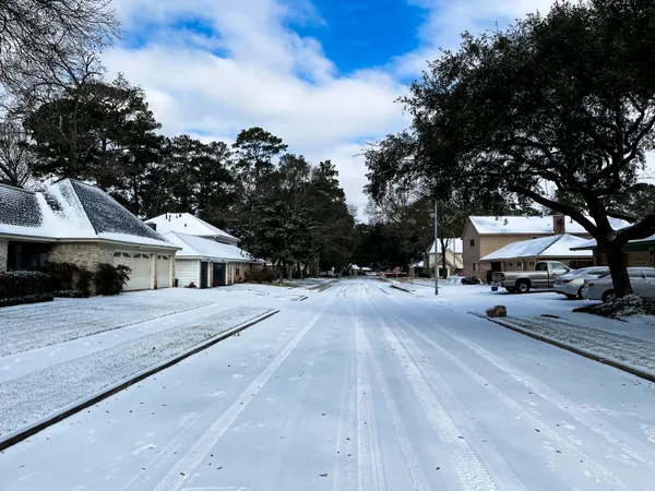
How this winter has behaved so far
Early winter in Houston leaned warmer than the traditional calendar would suggest, with the season’s first freeze arriving later than the long-term average. The city did record a brief freeze in mid-December at Bush Intercontinental Airport, marking the first sub-freezing reading since late February of the prior winter season.
While that confirms winter cold has reached the metro at least once, it does not establish that the final freeze has already occurred. Late-season cold fronts can still drive brief overnight freezes, especially in typically colder inland suburbs and outlying counties north and northwest of the urban core.
What to watch over the next several weeks
Front timing and cloud cover: The coldest nights usually follow the passage of a strong front, when skies clear and winds relax.
Urban versus outlying areas: Central Houston often stays a few degrees warmer than surrounding communities, making “near-freezing” a more common outcome downtown even when outlying areas dip below 32°F.
Impacts beyond pipes: Even when temperatures stay above 32°F, lows in the mid-30s can still support frost formation near the ground in sheltered locations, affecting sensitive plants.
Bottom line: Houston’s short-term forecast points away from freezing temperatures, but the historical freeze window remains open into late February and can extend later in rare years.